|
If you can see this text here you should update to a newer web browser Normal | Highlight & Comment Comments/corrections will appear in yellow like this |
NAVAER AIR INFORMATION SUMMARY #19 = = = = = = = = = = = = = = = = = = = = = = = = = = = = = = = = = = = = = Distribution: Standard Air Information Branch Distribution - - - - - - - - - - - - - - - - - - - - - - - - - - - - - - - - - - - - - NAVIGATIONAL USES OF ASB RADAR The Aircraft Experimental and Development Squadron has submitted a report (Enclosure (A)) on the navigational uses of ASB Radar. This report is an investigation of researches by Lieutenant Arthur E. Tanner, A-V(RS), who, in the training of operational instructors in the use of ASB Radar installed in TBF airplanes, discovered a method of determining actual wind direction at sea and developed a system of land navigation. Other reports on ASB Radar appear in Air Information Summary No. 8, "Operational Tests of ASB Radar Installation in TBF Aircraft", 24 April 1943, and in Air information Summary, No. 9, "Operational Tests of ASB Radar in Low Level Bombing," 22 June 1943. The ASB Radar was a 515 MHz aircraft-borne radar system and was the frst US-built carrier-capable aircraft radar set when carried by the TBF Avenger. It featured Yagi-style antennas under each wing, and over 26,000 were built.
|
|
U. S. CONFIDENTIAL ENCLOSURE (A) - REPORT NAVIGATIONAL USES OF ASB RADAR
ENCLOSURE (A)
|
|||||||||||||||||||||||||||||||||||||||
|
U. S. CONFIDENTIAL
- 2 -
|
||||||||||||||||||||||||||||||||||||||||||||||||
|
U. S. CONFIDENTIAL
- 3 -
|
||||||||
|
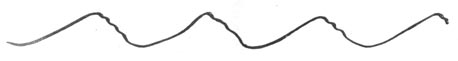
U. S. CONFIDENTIAL ENCLOSURE (B) - Lt. Arthur E. Tanner's Letter Subject: Additional Uses of ASB Radar in Navigation. 1. While training operational instructors in the use of ASB radar installed in the TBF airplanes, a method of determining a actual wind direction at sea was discovered and a system of land navigation was developed. These involve no changes in standard switching and reporting procedure, but concern only antenna rotation and screen interpretation. 2. For some time radar operators have been able to tell if they were flying cross-wind, or with the wind, because the sea returns are much lower when reflected from the troughs of the waves. This study goes one step further and determines the actual wind direction relative to the course of the airplane, because the characteristics of the returns from the windward and lee slopes of the wave fronts very definitely differ on the indicator, thus giving a positive determination of wind direction. These differences are barely perceptible at 5 knots wind, while with a wind of 25 knots the lee slopes give large reflections similar to a number of airplanes at 2 miles, and the windward slopes are still rather smooth, giving reflection from less than 1 mile.
Usually the windward slopes are longer and smoother, while the lee slopes are shorter, steeper, and more broken. If the airplane is flying cross-wind (into the previous page) with the antennas on search, the port and starboard sides of the trace would appear as sketched below:
ENCLOSURE (B)
|
|
U. S. CONFIDENTIAL The long, smooth windward slopes give a much stronger echo at close range while the steep lee slope gives a return from a greater distance, even through the echo is not so strong. This held true for altitudes of 500 to 2500 feet. In all cases of cross-wind flying the homing antenna positions would show definitely lower sea returns than the search. (THESE OBSERVATIONS ARE VALID ONLY WHEN PLANE IS IN LEVEL FLIGHT). 3. In case the sea returns are less on search than on homing, the plane must be flying up or down wind, and a 45 degree change of course for a few seconds should enable the operator to determine whether he has a head or tail wind. In case the plane turns 45 degrees to port or starboard, rotating the antenna on that side only will give the indication for the check, while the other antenna is left stationary for a comparison. Suppose the pilot turned the plane 45 degrees to starboard, and the picture on the scope looks like this when starboard antenna is rotated:
Then, according to the wave-front theory, the plane must now be quartering the wind, which is now coming from 45 degrees off the port bow, and the original direction must have been into the wind. In case the pilot turns 45 degrees to starboard, and the characteristic wave front picture is reversed when the starboard antenna is rotated, the plane must have been flying with a tail wind. In case the pilot chooses to turn to port, the port antenna would be used and the indicator pictures reversed. If the plane is already quartering the wind, the direction of troughs of the waves can be read rather accurately within possibly 20 degrees, as the antenna is rotated, and the relative direction of the null noted as above. The beam from the ASB antenna is surprisingly sharp. If the pilot makes a 90 degrees turn to fly cross-wind, the direction could be noted beyond any doubt, but operator must be sure wings are level before being too certain of his interpretation. - 2 -
|
|
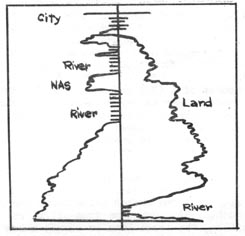
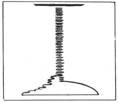
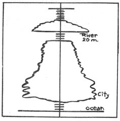
U. S. CONFIDENTIAL 4. By carefully noting the height and roughness of the sea-returns at various times (but at same altitude) in comparison with the picture at the start of the flight, the experienced operator will know if the wind is increasing or diminishing, and should inform the pilot of these changes in direction and velocity to check with the flight plan. This information will minimize the number of serious navigational errors that often result from unpredicted changes in wind direction and velocity. 5. In the absence of a (YJ) radar beacon, for ASB gear, it was desired to find targets to use as navigational aids over land. It was found that land targets were not reliable as strong echos often faded out completely as we approached closer than 3 miles (possibly because of lack of reflection as target angle changed). Land target navigation was given up in disgust when two small trucks gave a stronger echo than a large factory building. Navigation by using the absence of echos, which indicate bodies of water, was tried with immediate success. Water maps of the Jacksonville area could be drawn by a judicious study of the scope as the two ASB antennae were rotated. The sketch below shows the geography of the Florida coast approaching St. Augustine from off shore. Both antennae were in homing position, the coast line is seen 3 miles ahead, the strong land targets indicate the buildings of the city, and the St. Johns River, 2 miles wide, is distinctly seen at a distance of 20 miles. The strong echo at that distance is only the opposite river bank.
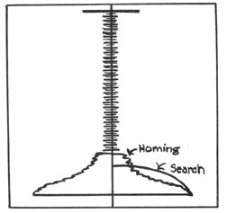
6. The pilot decided to find the Naval Air Station by flying north along the west bank of the St. Johns river, so the port antenna was set on homing, the starboard on search. When on course, the indicator looked as below: - 3 -
|
|
U. S. CONFIDENTIAL
Even witih a very low ceiling it should be possible to find the home landing field and know when to let down. Radar planes operating in the Alaskan area, have used coast-line navigation for some time and it was found possible to draw rather accurate maps of the coast of Florida, plotting headlands, jetties, harbor and river mouths. By rotating antennae and noting distances to channels in the various directions, water maps could be drawn of the land areas within the line of sight range of about 26 miles. In the mountainous areas the land navigation would present a different problem, but in this flat area, water-channel navigation proved very useful when flying over land. - 4 -
|